 AfricaSRTM-MtKilimanjaro-picasa.jpg
NASA/JPL/NIMA. "AfricaSRTM-MtKilimanjaro-picasa.jpg" Online Image. Shuttle Radar Topography Mission. 20 Jan. 2006 69kb. 1373x209px. <http://photojournal.jpl.nasa.gov/catalog/PIA03355>
This image shows a perspective view created by draping a Landsat image over the elevation framework from an SRTM data set for Mt. Kilimanjaro. It was created from an original map produced from data obtained by NASA's Shuttle Radar Topography Mission (SRTM). Using Google's free Picasa2 program, the color and lighting were enhanced and then sharpened to obtain the image above. The original image can be viewed at the NASA link above.
 AfricaSRTM-RichatStructure-picasa.jpg
NASA/JPL/NIMA. "AfricaSRTM-RichatStructure-picasa.jpg" Online Image. Shuttle Radar Topography Mission. 20 Jan. 2006 87kb. 778x428px. <http://photojournal.jpl.nasa.gov/catalog/PIA04963>
This image shows a perspective view created by draping a Landsat image over the elevation framework from an SRTM data set for the Richat Structure. It was created from an original map produced from data obtained by NASA's Shuttle Radar Topography Mission (SRTM). Using Google's free Picasa2 program, the color, contrast, and lighting were enhanced. It was then sharpened to obtain the image above. The original image can be viewed at the NASA link above.
 AfricaSRTM-SatelliteNile-picasa.jpg
NASA/GSFC/JPL, MISR Team. “AfricaSRTM-SatelliteNile-picasa.jpg” Online Image. Shuttle Radar Topography Mission. 16 May 2005 65kb. 553×602px. <http://photojournal.jpl.nasa.gov/jpegMod/PIA02647_modest.jpg>
This image shows a satellite photo of Egypt in Africa. It was created from a satellite photo produced by NASA's Shuttle Radar Topography Mission (SRTM). Using Google's free Picasa2 program, the color and lighting were enhanced and then sharpened to obtain the image above. The original image can be viewed at the NASA link above.
 AfricaSRTM-SinaiPeninsula-picasa.jpg
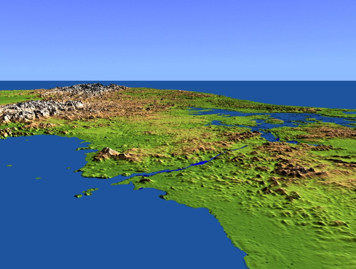
NASA/JPL/NIMA. "AfricaSRTM-SinaiPeninsula-picasa.jpg" Online Image. Shuttle Radar Topography Mission. 20 Jan. 2006 58kb. 417x799px. <http://photojournal.jpl.nasa.gov/catalog/PIA04957>
This image shows an SRTM data set for the Sinai Peninsula in Egypt. It was created from an original map produced from data obtained by NASA's Shuttle Radar Topography Mission (SRTM). Using Google's free Picasa2 program, the color, contrast, and lighting were enhanced to obtain the image above. The original image can be viewed at the NASA link above.
 AfricaSRTM-Water-picasa.jpg
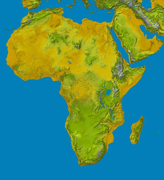
NASA/JPL/NIMA. “AfricaSRTM-Water-picasa.jpg” Online Image. Shuttle Radar Topography Mission. 16 May 2005 73kb. 552×604px. <http://photojournal.jpl.nasa.gov/jpegMod/PIA04965_modest.jpg>
This image shows an SRTM data set for the continent of Africa. It includes water, ie lakes rivers, etc. added in. It was created from an original map produced from data obtained by NASA's Shuttle Radar Topography Mission (SRTM). Using Google's free Picasa2 program, the color and lighting were enhanced and then sharpened to obtain the image above. The original image can be viewed at the NASA link above. (An important note for this image if you have looked at other SRTM data maps, is that the green and yellow colors have obviously been reversed from the Africa map with normal SRTM coloration, probably by mistake.)
 AfricaWMGP2Large-picasa.jpg
NASA/JPL/NIMA. “AfricaWMGP2Large-picasa.jpg” Online Image. Earth Observatory. 16 May 2005 773kb. 2133×2361px. <http://earthobservatory.nasa.gov/Newsroom/NewImages/Images/PIA03395_lrg.jpg>
This image shows an SRTM data set for the continent of Africa. It was created from a larger Public Domain world map, WorldSRTM-MercatorLarge-picasa.jpg, produced from data obtained by NASA's Shuttle Radar Topography Mission (SRTM). The world map was cropped to Africa and resized to double size using a trial version of Adobe Photoshop. Using Google's free Picasa2 program, the color and lighting were then enhanced and finally sharpened to obtain the image above. The original image can be viewed at the NASA link above.
AfricaWMGP600-picasa.jpg
NASA/JPL/NIMA. “AfricaWMGP600-picasa.jpg” Online Image. Earth Observatory. 16 May 2005 91kb. 600×664px. <http://earthobservatory.nasa.gov/Newsroom/NewImages/Images/PIA03395_lrg.jpg>
This image shows an SRTM data set for the continent of Africa. It was created from a larger Public Domain world map, WorldSRTM-MercatorLarge-picasa.jpg, produced from data obtained by NASA's Shuttle Radar Topography Mission (SRTM). The world map was cropped to Africa and resized to 600 pixels wide using a trial version of Adobe Photoshop. Using Google's free Picasa2 program, the color and lighting were then enhanced and finally sharpened to obtain the image above. The original image can be viewed at the NASA link above.
AfricaWMGPLarge-picasa.jpg
NASA/JPL/NIMA. “AfricaWMGPLarge-picasa.jpg” Online Image. Earth Observatory. 16 May 2005 353kb. 1202×1209px. <http://earthobservatory.nasa.gov/Newsroom/NewImages/Images/PIA03395_lrg.jpg>
This image shows an SRTM data set for the continent of Africa. It was created from a larger Public Domain world map, WorldSRTM-MercatorLarge-picasa.jpg, produced from data obtained by NASA's Shuttle Radar Topography Mission (SRTM). The world map was cropped to Africa using a trial version of Adobe Photoshop. Using Google's free Picasa2 program, the color and lighting were then enhanced and finally sharpened to obtain the image above. The original image can be viewed at the NASA link above.
 AmericaSRTM-Central2Large-picasa.jpg
NASA/JPL/NIMA. “AmericaSRTM-Central2Large-picasa.jpg” Online Image. Earth Observatory. 16 May 2005 182kb. 1764×850px. <http://earthobservatory.nasa.gov/Newsroom/NewImages/Images/PIA03395_lrg.jpg>
This image shows an SRTM data set for Central America. It was created from a larger Public Domain world map, WorldSRTM-MercatorLarge-picasa.jpg, produced from data obtained by NASA's Shuttle Radar Topography Mission (SRTM). The world map was cropped to Central America and resized to double size using a trial version of Adobe Photoshop. Using Google's free Picasa2 program, the color and lighting were then enhanced and finally sharpened to obtain the image above. The original image can be viewed at the NASA link above.
AmericaSRTM-Central600-picasa.jpg
NASA/JPL/NIMA. “AmericaSRTM-Central600-picasa.jpg” Online Image. Earth Observatory. 16 May 2005 37kb. 600×279px. <http://earthobservatory.nasa.gov/Newsroom/NewImages/Images/PIA03395_lrg.jpg>
This image shows an SRTM data set for Central America. It includes water, ie lakes rivers, etc. added in. It was created from a larger Public Domain world map, WorldSRTM-MercatorLarge-picasa.jpg, produced from data obtained by NASA's Shuttle Radar Topography Mission (SRTM). The world map was cropped to Central America and resized to 600 pixels wide using a trial version of Adobe Photoshop. Using Google's free Picasa2 program, the color and lighting were then enhanced and finally sharpened to obtain the image above. The original image can be viewed at the NASA link above.
AmericaSRTM-CentralLarge-picasa.jpg
NASA/JPL/NIMA. “AmericaSRTM-CentralLarge-picasa.jpg” Online Image. Earth Observatory. 16 May 2005 82kb. 905×422px. <http://earthobservatory.nasa.gov/Newsroom/NewImages/Images/PIA03395_lrg.jpg>
This image shows an SRTM data set for Central America. It was created from a larger Public Domain world map, WorldSRTM-MercatorLarge-picasa.jpg, produced from data obtained by NASA's Shuttle Radar Topography Mission (SRTM). The world map was cropped to Central America using a trial version of Adobe Photoshop. Using Google's free Picasa2 program, the color and lighting were then enhanced and finally sharpened to obtain the image above. The original image can be viewed at the NASA link above.
 AmericaSRTM-CentralPanamaCanal-picasa.jpg
NASA/JPL/NIMA. "AmericaSRTM-CentralPanamaCanal-picasa.jpg" Online Image. Shuttle Radar Topography Mission. 20 Jan. 2006 185kb. 1152x870px. <http://photojournal.jpl.nasa.gov/jpeg/PIA03368.jpg>
This image shows a perspective view created by draping a Landsat image over the elevation framework from an SRTM data set for the Panama Canal. It was created from an original map produced from data obtained by NASA's Shuttle Radar Topography Mission (SRTM). Using Google's free Picasa2 program, the color, contrast, and lighting were enhanced to obtain the image above. The original image can be viewed at the NASA link above.
 AmericaSRTM-CentralWater-picasa.jpg
NASA/JPL/NIMA. “AmericaSRTM-CentralWater-picasa.jpg” Online Image. Shuttle Radar Topography Mission. 16 May 2005 48kb. 596×559px. <http://photojournal.jpl.nasa.gov/jpegMod/PIA03364_modest.jpg>
Size: 1720 by 1670 kilometers (1068 by 1036 miles)
Location: 14.5 degrees North latitude, 85.0 degrees West longitude
Orientation: North toward the top
Image Data: Shaded and colored SRTM elevation model
Date Acquired: February 2000
This image shows an SRTM data set for Central America. It includes water, ie lakes rivers, etc. added in. It was created from an original map produced from data obtained by NASA's Shuttle Radar Topography Mission (SRTM). Using Google's free Picasa2 program, the color and lighting were enhanced and then sharpened to obtain the image above. The original image can be viewed at the NASA link above.
 AmericaSRTM-North2Large-picasa.jpg
NASA/JPL/NIMA. “AmericaSRTM-North2Large-picasa.jpg” Online Image. Earth Observatory. 16 May 2005 708kb. 2736×1565px. <http://earthobservatory.nasa.gov/Newsroom/NewImages/Images/PIA03395_lrg.jpg>
This image shows an SRTM data set for the continent North America. It was created from a larger Public Domain world map, WorldSRTM-MercatorLarge-picasa.jpg, produced from data obtained by NASA's Shuttle Radar Topography Mission (SRTM). The world map was cropped to North America and resized to double size using a trial version of Adobe Photoshop. Using Google's free Picasa2 program, the color and lighting were then enhanced and finally sharpened to obtain the image above. The original image can be viewed at the NASA link above.
AmericaSRTM-North600-picasa.jpg
NASA/JPL/NIMA. “AmericaSRTM-North600-picasa.jpg” Online Image. Earth Observatory. 16 May 2005 61kb. 600×343px. <http://earthobservatory.nasa.gov/Newsroom/NewImages/Images/PIA03395_lrg.jpg>
This image shows an SRTM data set for the continent North America. It was created from a larger Public Domain world map, WorldSRTM-MercatorLarge-picasa.jpg, produced from data obtained by NASA's Shuttle Radar Topography Mission (SRTM). The world map was cropped to North America and resized to 600 pixels wide using a trial version of Adobe Photoshop. Using Google's free Picasa2 program, the color and lighting were then enhanced and finally sharpened to obtain the image above. The original image can be viewed at the NASA link above.
AmericaSRTM-NorthLarge-picasa.jpg
NASA/JPL/NIMA. “AmericaSRTM-NorthLarge-picasa.jpg” Online Image. Earth Observatory. 16 May 2005 374kb. 1395×1046px. <http://earthobservatory.nasa.gov/Newsroom/NewImages/Images/PIA03395_lrg.jpg>
This image shows an SRTM data set for the continent North America. It was created from a larger Public Domain world map, WorldSRTM-MercatorLarge-picasa.jpg, produced from data obtained by NASA's Shuttle Radar Topography Mission (SRTM). The world map was cropped to North America using a trial version of Adobe Photoshop. Using Google's free Picasa2 program, the color and lighting were then enhanced and finally sharpened to obtain the image above. The original image can be viewed at the NASA link above.
 AmericaSRTM-NorthLosAngeles-picasa.jpg
NASA/JPL/NIMA. "AmericaSRTM-NorthLosAngeles-picasa.jpg" Online Image. Shuttle Radar Topography Mission. 20 Jan. 2006 143kb. 886x375px. <http://photojournal.jpl.nasa.gov/jpegMod/PIA03376_modest.jpg>
This image shows a perspective view created by draping a Landsat image over the elevation framework from an SRTM data set for the city of Los Angeles. It was created from an original map produced from data obtained by NASA's Shuttle Radar Topography Mission (SRTM). Using Google's free Picasa2 program, the color, contrast, and lighting were enhanced. It was then sharpened to obtain the image above. The original image can be viewed at the NASA link above.
 AmericaSRTM-NorthMalaspinaGlacier-picasa.jpg
NASA/JPL/NIMA. "AmericaSRTM-NorthMalaspinaGlacier-picasa.jpg" Online Image. Shuttle Radar Topography Mission. 20 Jan. 2006 113kb. 816x408px. <http://photojournal.jpl.nasa.gov/catalog/PIA03386>
This image shows a perspective view created by draping a Landsat image over the elevation framework from an SRTM data set for Malaspina Glacier. It was created from an original map produced from data obtained by NASA's Shuttle Radar Topography Mission (SRTM). Using Google's free Picasa2 program, the color, contrast, and lighting were enhanced. It was then sharpened to obtain the image above. The original image can be viewed at the NASA link above.
 AmericaSRTM-NorthMtStHelens-picasa.jpg
NASA/JPL/NGA. "AmericaSRTM-NorthMtStHelens-picasa.jpg" Online Image. Shuttle Radar Topography Mission. 20 Jan. 2006 90kb. 665x500px. <http://photojournal.jpl.nasa.gov/catalog/PIA06668>
This image shows a perspective view created by draping a Landsat image over the elevation framework from an SRTM data set for Mt. St. Helens. It was created from an original map produced from data obtained by NASA's Shuttle Radar Topography Mission (SRTM). Using Google's free Picasa2 program, the color, contrast, and lighting were enhanced. It was then sharpened to obtain the image above. The original image can be viewed at the NASA link above.
 AmericaSRTM-NorthPortland-picasa.jpg
NASA/JPL/NIMA. "AmericaSRTM-NorthPortland-picasa.jpg" Online Image. Shuttle Radar Topography Mission. 20 Jan. 2006 119kb. 944x353px. <http://photojournal.jpl.nasa.gov/catalog/PIA04966>
This image shows a perspective view created by draping a Landsat image over the elevation framework from an SRTM data set for Mt. Hood and the city of Portland. It was created from an original map produced from data obtained by NASA's Shuttle Radar Topography Mission (SRTM). Using Google's free Picasa2 program, the color, contrast, and lighting were enhanced. It was then sharpened to obtain the image above. The original image can be viewed at the NASA link above.
 AmericaSRTM-NorthSanDiego-picasa.jpg
NASA/JPL/NIMA. “AmericaSRTM-NorthSanDiego-picasa.jpg” Online Image. Shuttle Radar Topography Mission. 20 Jan. 2006 97kb. 727x458px. <http://photojournal.jpl.nasa.gov/catalog/PIA03330>
This image shows a perspective view created by draping a Landsat image over the elevation framework from an SRTM data set for the city of San Diego. It was created from an original map produced from data obtained by NASA's Shuttle Radar Topography Mission (SRTM). Using Google's free Picasa2 program, the contrast was enhanced, and a fill light and glow were added to brighten the image. It was then sharpened to obtain the image above. The original image can be viewed at the NASA link above.
 AmericaSRTM-NorthSatellite-picasa.jpg
NASA image courtesy GSFC/LaRC/JPL MISR Team. “AmericaSRTM-NorthSatellite-picasa.jpg” Online Image. Shuttle Radar Topography Mission. 16 May 2005 46kb. 775×429px. <http://earthobservatory.nasa.gov/Newsroom/NewImages/images_topic.php3?topic=land&img_id=16585>
This image shows a satellite photo of the United States in North America. It was created from an original map produced from a mosaic of natural color satellite images obtained by NASA's Shuttle Radar Topography Mission (SRTM). Using Google's free Picasa2 program, the color and lighting were enhanced and then sharpened to obtain the image above. The original image can be viewed at the NASA link above.
 AmericaSRTM-NorthWater-picasa.jpg
NASA/JPL/NIMA. “AmericaSRTM-NorthWater-picasa.jpg” Online Image. Shuttle Radar Topography Mission. 16 May 2005 78kb. 664×501px. <http://photojournal.jpl.nasa.gov/jpegMod/PIA03377_modest.jpg>
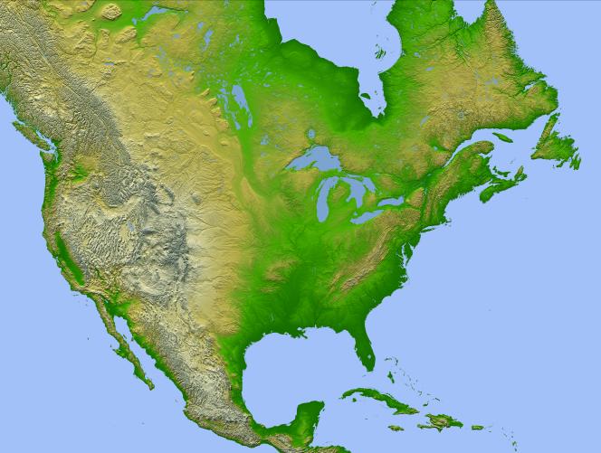
Location: 15 to 60 degrees North latitude, 50 to 130 degrees West longitude
Orientation: North toward the top, Mercator projection
Image Data: shaded and colored SRTM elevation model
Original Data Resolution: SRTM 1 arcsecond (about 30 meters or 98 feet)
Date Acquired: February 2000
This image shows an SRTM data set for the continent North America. It includes water, ie lakes rivers, etc. added in. It was created from an original map produced from data obtained by NASA's Shuttle Radar Topography Mission (SRTM). Using Google's free Picasa2 program, the color and lighting were enhanced and then sharpened to obtain the image above. The original image can be viewed at the NASA link above.
 AmericaSRTM-South2Large-picasa.jpg
NASA/JPL/NIMA. “AmericaSRTM-South2Large-picasa.jpg” Online Image. Earth Observatory. 16 May 2005 479kb. 1444×2472px. <http://earthobservatory.nasa.gov/Newsroom/NewImages/Images/PIA03395_lrg.jpg>
This image shows an SRTM data set for the continent South America. It was created from a larger Public Domain world map, WorldSRTM-MercatorLarge-picasa.jpg, produced from data obtained by NASA's Shuttle Radar Topography Mission (SRTM). The world map was cropped to South America and resized to double size using a trial version of Adobe Photoshop. Using Google's free Picasa2 program, the color and lighting were then enhanced and finally sharpened to obtain the image above. The original image can be viewed at the NASA link above.
AmericaSRTM-South600-picasa.jpg
NASA/JPL/NIMA. “AmericaSRTM-South600-picasa.jpg” Online Image. Earth Observatory. 16 May 2005 135kb. 600×1036. <http://earthobservatory.nasa.gov/Newsroom/NewImages/Images/PIA03395_lrg.jpg>
This image shows an SRTM data set for the continent South America. It was created from a larger Public Domain world map, WorldSRTM-MercatorLarge-picasa.jpg, produced from data obtained by NASA's Shuttle Radar Topography Mission (SRTM). The world map was cropped to South America and resized to 600 pixels wide using a trial version of Adobe Photoshop. Using Google's free Picasa2 program, the color and lighting were then enhanced and finally sharpened to obtain the image above. The original image can be viewed at the NASA link above.
AmericaSRTM-SouthLarge-picasa.jpg
NASA/JPL/NIMA. “AmericaSRTM-SouthLarge-picasa.jpg” Online Image. Earth Observatory. 16 May 2005 241kb. 779×1239px. <http://earthobservatory.nasa.gov/Newsroom/NewImages/Images/PIA03395_lrg.jpg>
This image shows an SRTM data set for the continent South America. It was created from a larger Public Domain world map, WorldSRTM-MercatorLarge-picasa.jpg, produced from data obtained by NASA's Shuttle Radar Topography Mission (SRTM). The world map was cropped to South America using a trial version of Adobe Photoshop. Using Google's free Picasa2 program, the color and lighting were then enhanced and finally sharpened to obtain the image above. The original image can be viewed at the NASA link above.
 AmericaSRTM-SouthWater-picasa.jpg
NASA/JPL/NIMA. “AmericaSRTM-SouthWater-picasa.jpg” Online Image. Shuttle Radar Topography Mission. 16 May 2005 47kb. 469×709px. <http://photojournal.jpl.nasa.gov/jpegMod/PIA03388_modest.jpg>
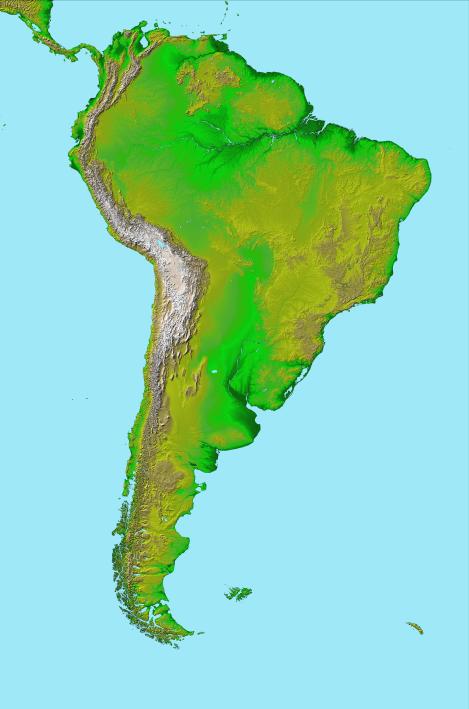
Location: 15 degrees North to 60 degrees South latitude, 30 to 90 degrees West longitude
Orientation: North toward the top, Mercator projection
Image Data: shaded and colored SRTM elevation model
Original Data Resolution: SRTM 1 arcsecond (about 30 meters or 98 feet)
Date Acquired: February 2000
This image shows an SRTM data set for the continent South America. It includes water, ie lakes rivers, etc. added in. It was created from an original map produced from data obtained by NASA's Shuttle Radar Topography Mission (SRTM). Using Google's free Picasa2 program, the color and lighting were enhanced and then sharpened to obtain the image above. The original image can be viewed at the NASA link above.
 AsiaSRTM-Bosporus-picasa.jpg
 AsiaSRTM-Bosporus-picasa.jpg
NASA/JPL/NIMA. “AsiaSRTM-Bosporus-picasa.jpg” Online Image. Shuttle Radar Topography Mission. 16 May 2005 108kb. 577×577px. <http://photojournal.jpl.nasa.gov/jpegMod/PIA03349_modest.jpg>
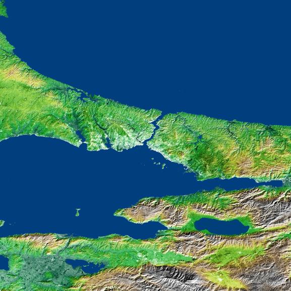
Size: 2x2 degrees (168 by 222 kilometers; 104 by 138 miles)
Location: 40-42 degrees North latitude, 28-30 degrees East longitude
Orientation: North toward the top
Image Data: shaded and colored SRTM elevation model, with SRTM radar intensity added
Original Data Resolution: SRTM 1 arcsecond (about 30 meters or 98 feet)
Date Acquired: February 2000 (SRTM)
This image shows an SRTM data set for Bosporus straits between Europe and Asia and separating the Black Sea (to the north) from the Sea of Marmara (to the South). It was created from an original map produced from data obtained by NASA's Shuttle Radar Topography Mission (SRTM). Using Google's free Picasa2 program, the color and lighting were enhanced and then sharpened to obtain the image above. The original image can be viewed at the NASA link above.
 AsiaSRTM-SriLankaWater-picasa.jpg
NASA/JPL/NGA. “AsiaSRTM-SriLankaWater-picasa.jpg” Online Image. Shuttle Radar Topography Mission. 16 May 2005 95kb. 438×759px. <http://photojournal.jpl.nasa.gov/jpegMod/PIA06670_modest.jpg>
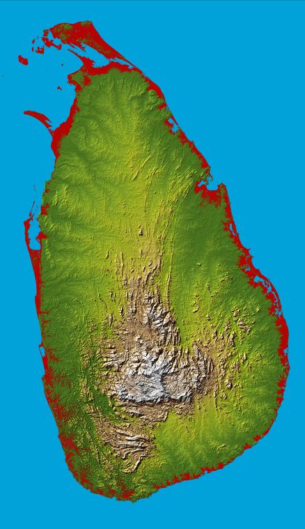
Location: 8.0 degrees North latitude, 80.7 degrees East longitude
Orientation: North toward the top, Mercator projection
Size: 275.6 by 482.4 kilometers (165.4 by 299.0 miles)
Image Data: shaded and colored SRTM elevation model
Date Acquired: February 2000
This image shows an SRTM data set for Sri Lanka. It was created from an original map produced from data obtained by NASA's Shuttle Radar Topography Mission (SRTM). Using Google's free Picasa2 program, the color and lighting were enhanced and then sharpened to obtain the image above. The original image can be viewed at the NASA link above.
 AsiaSRTM2Large-picasa.jpg
NASA/JPL/NIMA. “AsiaSRTM2Large-picasa.jpg” Online Image. Earth Observatory. 16 May 2005 1.37MB. 3648×2126px. <http://earthobservatory.nasa.gov/Newsroom/NewImages/Images/PIA03395_lrg.jpg>
This image shows an SRTM data set for the continent Asia. It was created from a larger Public Domain world map, WorldSRTM-MercatorLarge-picasa.jpg, produced from data obtained by NASA's Shuttle Radar Topography Mission (SRTM). The world map was cropped to Asia and resized to double size using a trial version of Adobe Photoshop. Using Google's free Picasa2 program, the color and lighting were then enhanced and finally sharpened to obtain the image above. The original image can be viewed at the NASA link above.
AsiaSRTM600-picasa.jpg
NASA/JPL/NIMA. “AsiaSRTM600-picasa.jpg” Online Image. Earth Observatory. 16 May 2005 77kb. 600×347px. <http://earthobservatory.nasa.gov/Newsroom/NewImages/Images/PIA03395_lrg.jpg>
This image shows an SRTM data set for the continent Asia. It was created from a larger Public Domain world map, WorldSRTM-MercatorLarge-picasa.jpg, produced from data obtained by NASA's Shuttle Radar Topography Mission (SRTM). The world map was cropped to Asia and resized to 600 pixels wide using a trial version of Adobe Photoshop. Using Google's free Picasa2 program, the color and lighting were then enhanced and finally sharpened to obtain the image above. The original image can be viewed at the NASA link above.
AsiaSRTMLarge-picasa.jpg
NASA/JPL/NIMA. “AsiaSRTMLarge-picasa.jpg” Online Image. Earth Observatory. 16 May 2005 473kb. 2221×1026px. <http://earthobservatory.nasa.gov/Newsroom/NewImages/Images/PIA03395_lrg.jpg>
This image shows an SRTM data set for the continent Asia. It was created from a larger Public Domain world map, WorldSRTM-MercatorLarge-picasa.jpg, produced from data obtained by NASA's Shuttle Radar Topography Mission (SRTM). The world map was cropped to Asia using a trial version of Adobe Photoshop. Using Google's free Picasa2 program, the color and lighting were then enhanced and finally sharpened to obtain the image above. The original image can be viewed at the NASA link above.
 AsiaWMGP-China2Large-picasa.jpg
NASA/JPL/NIMA. “AsiaWMGP-China2Large-picasa.jpg” Online Image. Earth Observatory. 16 May 2005 573kb. 1920×1113px. <http://earthobservatory.nasa.gov/Newsroom/NewImages/Images/PIA03395_lrg.jpg>
This image shows an SRTM data set for China. It was created from a larger Public Domain world map, WorldSRTM-MercatorLarge-picasa.jpg, produced from data obtained by NASA's Shuttle Radar Topography Mission (SRTM). The world map was cropped to China and resized to double size using a trial version of Adobe Photoshop. Using Google's free Picasa2 program, the color and lighting were then enhanced and finally sharpened to obtain the image above. The original image can be viewed at the NASA link above.
AsiaWMGP-China600-picasa.jpg
NASA/JPL/NIMA. “AsiaWMGP-China600-picasa.jpg” Online Image. Earth Observatory. 16 May 2005 91kb. 600×348px. <http://earthobservatory.nasa.gov/Newsroom/NewImages/Images/PIA03395_lrg.jpg>
This image shows an SRTM data set for China. It was created from a larger Public Domain world map, WorldSRTM-MercatorLarge-picasa.jpg, produced from data obtained by NASA's Shuttle Radar Topography Mission (SRTM). The world map was cropped to China and resized to 600 pixels wide using a trial version of Adobe Photoshop. Using Google's free Picasa2 program, the color and lighting were then enhanced and finally sharpened to obtain the image above. The original image can be viewed at the NASA link above.
AsiaWMGP-ChinaLarge-picasa.jpg
NASA/JPL/NIMA. “AsiaWMGP-ChinaLarge-picasa.jpg” Online Image. Earth Observatory. 16 May 2005 274kb. 1187×571px. <http://earthobservatory.nasa.gov/Newsroom/NewImages/Images/PIA03395_lrg.jpg>
This image shows an SRTM data set for China. It was created from a larger Public Domain world map, WorldSRTM-MercatorLarge-picasa.jpg, produced from data obtained by NASA's Shuttle Radar Topography Mission (SRTM). The world map was cropped to China using a trial version of Adobe Photoshop. Using Google's free Picasa2 program, the color and lighting were then enhanced and finally sharpened to obtain the image above. The original image can be viewed at the NASA link above.
 AsiaWMGP-India2Large-picasa.jpg
NASA/JPL/NIMA. “AsiaWMGP-India2Large-picasa.jpg” Online Image. Earth Observatory. 16 May 2005 216kb. 880×1154px. <http://earthobservatory.nasa.gov/Newsroom/NewImages/Images/PIA03395_lrg.jpg>
This image shows an SRTM data set for India. It was created from a larger Public Domain world map, WorldSRTM-MercatorLarge-picasa.jpg, produced from data obtained by NASA's Shuttle Radar Topography Mission (SRTM). The world map was cropped to India resized to double size using a trial version of Adobe Photoshop. Using Google's free Picasa2 program, the color and lighting were then enhanced and finally sharpened to obtain the image above. The original image can be viewed at the NASA link above.
AsiaWMGP-India600-picasa.jpg
NASA/JPL/NIMA. "AsiaWMGP-India600-picasa.jpg” Online Image. Earth Observatory. 16 May 2005 96kb. 572×585px. <http://earthobservatory.nasa.gov/Newsroom/NewImages/Images/PIA03395_lrg.jpg>
This image shows an SRTM data set for India. It was created from a larger Public Domain world map, WorldSRTM-MercatorLarge-picasa.jpg, produced from data obtained by NASA's Shuttle Radar Topography Mission (SRTM). The world map was cropped to India using a trial version of Adobe Photoshop. Using Google's free Picasa2 program, the color and lighting were then enhanced and finally sharpened to obtain the image above. The original image can be viewed at the NASA link above.
 AsiaWMGP-MiddleEast2Large-picasa.jpg
NASA/JPL/NIMA. “AsiaWMGP-MiddleEast2Large-picasa.jpg” Online Image. Earth Observatory. 16 May 2005 374kb. 1394×1361px. <http://earthobservatory.nasa.gov/Newsroom/NewImages/Images/PIA03395_lrg.jpg>
This image shows an SRTM data set for the Middle East. It was created from a larger Public Domain world map, WorldSRTM-MercatorLarge-picasa.jpg, produced from data obtained by NASA's Shuttle Radar Topography Mission (SRTM). The world map was cropped to the Middle East resized to double size using a trial version of Adobe Photoshop. Using Google's free Picasa2 program, the color and lighting were then enhanced and finally sharpened to obtain the image above. The original image can be viewed at the NASA link above.
AsiaWMGP-MiddleEast600-picasa.jpg
NASA/JPL/NIMA. “AsiaWMGP-MiddleEast600-picasa.jpg” Online Image. Earth Observatory. 16 May 2005 100kb. 600×449px. <http://earthobservatory.nasa.gov/Newsroom/NewImages/Images/PIA03395_lrg.jpg>
This image shows an SRTM data set for the Middle East. It was created from a larger Public Domain world map, WorldSRTM-MercatorLarge-picasa.jpg, produced from data obtained by NASA's Shuttle Radar Topography Mission (SRTM). The world map was cropped to the Middle East and resized to 600 pixels wide using a trial version of Adobe Photoshop. Using Google's free Picasa2 program, the color and lighting were then enhanced and finally sharpened to obtain the image above. The original image can be viewed at the NASA link above.
 colorcube.png
darth333vader. “colorcube.png” 03 Dec. 2005. Image. 50kb. 250×570px.
This image shows the color cube of the 216 Web Safe Colors. It was created from scratch in MS Paint by darth333vader.
DICAltText.jpg
darth333vader. “DICAltText.jpg” 19 Aug. 2005. Image. 27kb. 449×237px.
This image shows a screen shot of EarthChronicle.com, with Alt Text indicated. It was created from a screen shot and edited in MS Paint by darth333vader.
DICTitleBar.jpg
darth333vader. “DICTitleBar.jpg” 19 Aug. 2005. Image. 20kb. 453×238px.
This image shows a screen shot of EarthChronicle.com, with the Title Bar indicated. It was created from a screen shot and edited in MS Paint by darth333vader.
 EuropeSatelliteGreece-picasa.jpg
 EuropeSatelliteGreece-picasa.jpg
Courtesy of MODIS Rapid Response Project at NASA/GSFC. “EuropeSatelliteGreece-picasa.jpg” 19 Aug. 2004. Online Image. Earth Observatory. 16 May 2005 99kb. 540×540px. <http://earthobservatory.nasa.gov/Newsroom/NewImages/images_topic.php3?topic=land&img_id=16649>
This image shows a satellite photo of Greece in Europe with international boundaries added in white. This true-color image was acquired on January 28, 2004, by the Moderate Resolution Imaging Spectroradiometer (MODIS) on the Aqua satellite. It was created from a satellite photo produced by NASA. Using Google's free Picasa2 program, the color and lighting were enhanced and then sharpened to obtain the image above. The original image can be viewed at the NASA link above.
 EuropeSatelliteIceland.jpg
Courtesy of MODIS Rapid Response Project at NASA/GSFC. “EuropeSatelliteIceland.jpg” 28 Jan. 2004. Online Image. Earth Observatory. 3 Feb. 2006 68kb. 540×405px. <http://earthobservatory.nasa.gov/Newsroom/NewImages/Images/image02022004.jpg>
This image shows a satellite photo of Iceland in Europe. The entire island is almost completely covered in the glistening white glaciers that have carved the intricate fjords, especially on the northwestern peninsula. This true-color image was acquired on January 28, 2004, by the Moderate Resolution Imaging Spectroradiometer (MODIS) on the Aqua satellite. Original photo unmodified; Picasa2 made very little difference. Original can also be viewed at the NASA link above.
 EuropeSRTM-FranceWater-picasa.jpg
NASA/JPL/NIMA. “EuropeSRTM-FranceWater-picasa.jpg” Online Image. Shuttle Radar Topography Mission. 16 May 2005 133kb. 590×563px. <http://photojournal.jpl.nasa.gov/jpegMod/PIA03393_modest.jpg>
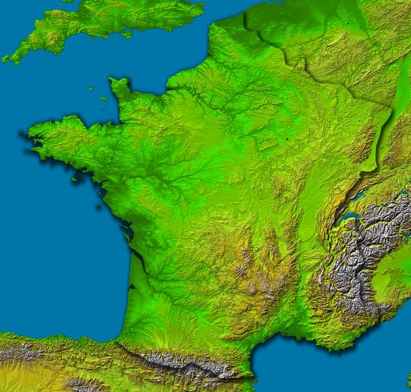
Location: 42 to 51.5 degrees North latitude, 5.5 West to 8 degrees East longitude
Orientation: North toward the top, Mercator projection
Image Data: shaded and colored SRTM elevation model
Original Data Resolution: SRTM 1 arcsecond (about 30 meters or 98 feet)
Date Acquired: February 2000
This image shows an SRTM data set for region of France in Europe. It includes water, ie lakes rivers, etc. added in. It was created from an original map produced from data obtained by NASA's Shuttle Radar Topography Mission (SRTM). Using Google's free Picasa2 program, the color and lighting were enhanced and then sharpened to obtain the image above. The original image can be viewed at the NASA link above.
 EuropeSRTM-IrelandWater-picasa.jpg
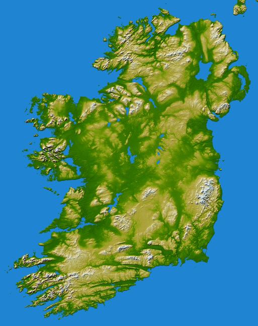
NASA/JPL/NGA. “EuropeSRTM-IrelandWater-picasa.jpg” Online Image. Shuttle Radar Topography Mission. 16 May 2005 90kb. 513×649px. <http://photojournal.jpl.nasa.gov/jpegMod/PIA06672_modest.jpg>
Location: 53.5 degrees North latitude, 8 degrees West longitude
Orientation: North toward the top, Mercator projection
Image Data: shaded and colored SRTM elevation model
Date Acquired: February 2000
This image shows an SRTM data set for Ireland in Europe. It includes water, ie lakes rivers, etc. added in. It was created from an original map produced from data obtained by NASA's Shuttle Radar Topography Mission (SRTM). Using Google's free Picasa2 program, the color and lighting were enhanced and then sharpened to obtain the image above. The original image can be viewed at the NASA link above.
 EuropeWMGP2Large-picasa.jpg
NASA/JPL/NIMA. “EuropeWMGP2Large-picasa.jpg” Online Image. Earth Observatory. 16 May 2005 558kb. 2198×1125px. <http://earthobservatory.nasa.gov/Newsroom/NewImages/Images/PIA03395_lrg.jpg>
This image shows an SRTM data set for the continent of Europe. It was created from a larger Public Domain world map, WorldSRTM-MercatorLarge-picasa.jpg, produced from data obtained by NASA's Shuttle Radar Topography Mission (SRTM). The world map was cropped to Europe and resized to double size using a trial version of Adobe Photoshop. Using Google's free Picasa2 program, the color and lighting were then enhanced and finally sharpened to obtain the image above. The original image can be viewed at the NASA link above.
EuropeWMGP600-picasa.jpg
NASA/JPL/NIMA. “EuropeWMGP600-picasa.jpg” Online Image. Earth Observatory. 16 May 2005 71kb. 600×307px. <http://earthobservatory.nasa.gov/Newsroom/NewImages/Images/PIA03395_lrg.jpg>
This image shows an SRTM data set for the continent of Europe. It was created from a larger Public Domain world map, WorldSRTM-MercatorLarge-picasa.jpg, produced from data obtained by NASA's Shuttle Radar Topography Mission (SRTM). The world map was cropped to Europe and resized to 600 pixels wide using a trial version of Adobe Photoshop. Using Google's free Picasa2 program, the color and lighting were then enhanced and finally sharpened to obtain the image above. The original image can be viewed at the NASA link above.
EuropeWMGPLarge-picasa.jpg
NASA/JPL/NIMA. “EuropeWMGPLarge-picasa.jpg” Online Image. Earth Observatory. 16 May 2005 258kb. 1172×564px. <http://earthobservatory.nasa.gov/Newsroom/NewImages/Images/PIA03395_lrg.jpg>
This image shows an SRTM data set for the continent of Europe. It was created from a larger Public Domain world map, WorldSRTM-MercatorLarge-picasa.jpg, produced from data obtained by NASA's Shuttle Radar Topography Mission (SRTM). The world map was cropped to Europe using a trial version of Adobe Photoshop. Using Google's free Picasa2 program, the color and lighting were then enhanced and finally sharpened to obtain the image above. The original image can be viewed at the NASA link above.
 OceaniaSRTM-Australia2Large-picasa.jpg
NASA/JPL/NIMA. “OceaniaSRTM-Australia2Large-picasa.jpg” Online Image. Earth Observatory. 16 May 2005 188kb. 1327×981px. <http://earthobservatory.nasa.gov/Newsroom/NewImages/Images/PIA03395_lrg.jpg>
This image shows an SRTM data set for the continent of Australia. It was created from a larger Public Domain world map, WorldSRTM-MercatorLarge-picasa.jpg, produced from data obtained by NASA's Shuttle Radar Topography Mission (SRTM). The world map was cropped to Australia resized to double size using a trial version of Adobe Photoshop. Using Google's free Picasa2 program, the color and lighting were then enhanced and finally sharpened to obtain the image above. The original image can be viewed at the NASA link above.
OceaniaSRTM-Australia600-picasa.jpg
NASA/JPL/NIMA. “OceaniaSRTM-Australia600-picasa.jpg” Online Image. Earth Observatory. 16 May 2005 55kb. 600×444px. <http://earthobservatory.nasa.gov/Newsroom/NewImages/Images/PIA03395_lrg.jpg>
This image shows an SRTM data set for the continent of Australia. It was created from a larger Public Domain world map, WorldSRTM-MercatorLarge-picasa.jpg, produced from data obtained by NASA's Shuttle Radar Topography Mission (SRTM). The world map was cropped to Australia and resized to 600 pixels wide using a trial version of Adobe Photoshop. Using Google's free Picasa2 program, the color and lighting were then enhanced and finally sharpened to obtain the image above. The original image can be viewed at the NASA link above.
 OceaniaSRTM-AustraliaWater-picasa.jpg
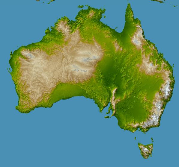
NASA/JPL/NGA. “OceaniaSRTM-AustraliaWater-picasa.jpg” Online Image. Shuttle Radar Topography Mission. 16 May 2005 60kb. 597×558px. <http://photojournal.jpl.nasa.gov/jpegMod/PIA06665_modest.jpg>
Location: 45 to 10 degrees South latitude, 112 to 155 degrees East longitude
Orientation: North toward the top, Mercator projection
Image Data: shaded and colored SRTM elevation model
Date Acquired: February 2000
This image shows an SRTM data set for the continent of Australia. It was created from an original map produced from data obtained by NASA's Shuttle Radar Topography Mission (SRTM). Using Google's free Picasa2 program, the color and lighting were enhanced and then sharpened to obtain the image above. The original image can be viewed at the NASA link above.
 OceaniaSRTM-NewZealandWater-picasa.jpg
NASA/JPL/NGA. “OceaniaSRTM-NewZealandWater-picasa.jpg” Online Image. Shuttle Radar Topography Mission. 16 May 2005 29kb. 508×655px. <http://photojournal.jpl.nasa.gov/jpegMod/PIA06662_modest.jpg>
Location: 33.5 to 48 degrees South latitude, 165 to 180 degrees East longitude
Orientation: North toward the top, cylindrical projection
Image Data: Shaded and colored SRTM elevation model
Date Acquired: February 2000
This image shows an SRTM data set for New Zealand in Oceania. It includes water, ie lakes rivers, etc. added in. It was created from an original map produced from data obtained by NASA's Shuttle Radar Topography Mission (SRTM). Using Google's free Picasa2 program, the color and lighting were enhanced and then sharpened to obtain the image above. The original image can be viewed at the NASA link above.
 OceaniaSRTM-OahuHawaii-picasa.jpg
NASA/JPL/NIMA. "OceaniaSRTM-OahuHawaii-picasa.jpg" Online Image. Shuttle Radar Topography Mission. 20 Jan. 2006 82kb. 643x548px. <http://photojournal.jpl.nasa.gov/catalog/PIA02727>
This image shows a perspective view created by draping a Landsat image over the elevation framework from an SRTM data set for the island of Oahu. It was created from an original map produced from data obtained by NASA's Shuttle Radar Topography Mission (SRTM). Using Google's free Picasa2 program, the contrast was enhanced, and fill light was added to brighten the image. It was then sharpened, and the saturation and highlights were increased slightly to accentuate the colors of the image above. The original image can be viewed at the NASA link above.
 OceaniaWMGP2Large-picasa.jpg
NASA/JPL/NIMA. “OceaniaWMGP2Large-picasa.jpg” Online Image. Earth Observatory. 16 May 2005 879kb. 3915×2400px. <http://earthobservatory.nasa.gov/Newsroom/NewImages/Images/PIA03395_lrg.jpg>
This image shows an SRTM data set for Oceania. It was created from a larger Public Domain world map, WorldSRTM-MercatorLarge-picasa.jpg, produced from data obtained by NASA's Shuttle Radar Topography Mission (SRTM). The world map was cropped to Oceania resized to double size using a trial version of Adobe Photoshop. Using Google's free Picasa2 program, the color and lighting were then enhanced and finally sharpened to obtain the image above. The original image can be viewed at the NASA link above.
OceaniaWMGP600-picasa.jpg
NASA/JPL/NIMA. “OceaniaWMGP600-picasa.jpg” Online Image. Earth Observatory. 16 May 2005 39kb. 600×368px. <http://earthobservatory.nasa.gov/Newsroom/NewImages/Images/PIA03395_lrg.jpg>
This image shows an SRTM data set for Oceania. It was created from a larger Public Domain world map, WorldSRTM-MercatorLarge-picasa.jpg, produced from data obtained by NASA's Shuttle Radar Topography Mission (SRTM). The world map was cropped to Oceania and resized to 600 pixels wide using a trial version of Adobe Photoshop. Using Google's free Picasa2 program, the color and lighting were then enhanced and finally sharpened to obtain the image above. The original image can be viewed at the NASA link above.
 RainbowCrystals-picasa.jpg
darth333vader. “RainbowCrystals-picasa.jpg” 10 July 2005. Image. 14kb. 200×288px.
This image shows what look like rainbow crystals. It was created by darth333vader from scratch using a trial version of Adobe's Photoshop. After applying several bands of colors to form a test pattern, the image was created by experimenting with a random set of image textures.
RainbowCrystalslarge-picasa.jpg
darth333vader. “RainbowCrystalslarge-picasa.jpg” 10 July 2005. Image. 32kb. 347×500px.
This image shows what look like rainbow crystals. It was created by darth333vader from scratch using a trial version of Adobe's Photoshop. After applying several bands of colors to form a test pattern, the image was created by experimenting with a random set of image textures. It was enlarged to 500 pixels tall.
 SRTMshuttle.jpg
"SRTMshuttle.jpg" 19 Aug. 2005. Online Image. USGS. 21 Oct. 2005 10kb. 433×306px. <http://mac.usgs.gov/isb/pubs/factsheets/fs07103.html>
This image shows the Space Shuttle Endeavour and the 60m long SRTM antenna deployed for image acquisition. Original photo unmodified; Picasa2 made very little difference. Original can also be viewed at the USGS link above.
 WashingtonMonument-CherryTrees2005-picasa.jpg
darth333vader. “WashingtonMonument-CherryTrees2005-picasa.jpg” 09 July 2005. Image. 29kb. 300×400px.
This image shows a photo of the Washington Monument in Washinton D.C., the capitol of the United States. There are blossoming cherry trees in the foreground. It was created from an original photo. Using Google's free Picasa2 program, the color and lighting were enhanced to obtain the image above.
 WorldOceans-CrustalAge-picasa.jpg
 WorldOceans-CrustalAge-picasa.jpg
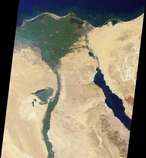
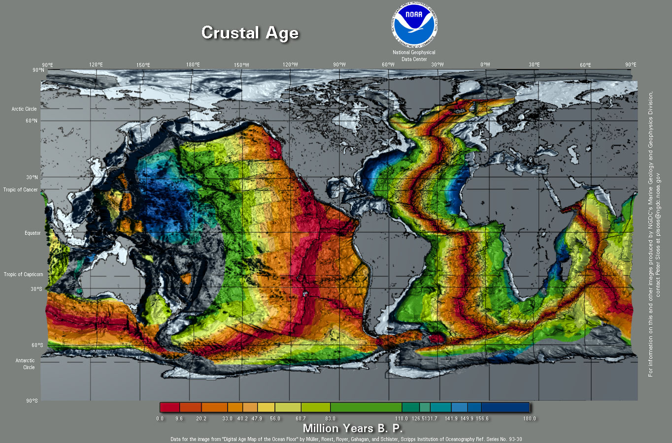
NGCD/NOAA/MGG. “WorldOceans-CrustalAge-picasa.jpg” Online Image. Marine Geology and Geophysics Division. 11 Jan. 2006 375kb. 1364×900px. <http://www.ngdc.noaa.gov/mgg/image/images/WorldCrustalAge.jpg>
This image shows the world's ocean floor. It was created from an original map produced from data obtained by NASA's Shuttle Radar Topography Mission (SRTM). Using Google's free Picasa2 program, the color and lighting were enhanced and then sharpened to obtain the image above. The original map is available at the NASA link above.
 WorldOutline-MercatorProjection-picasa.jpg
Graphic Maps. “WorldOutline-MercatorProjection-picasa.jpg” Online Image. Shuttle Radar Topography Mission. 16 May 2005 58kb. 694×403px. <http://worldatlas.com/aatlas/worldout.htm>
This image shows a black outline of the continents of the world as a Mercator projection. International boundaries are included. It was created from an original map produced by Graphic Maps. Using Google's free Picasa2 program, the color and lighting were enhanced to darken the lines of the image above. The original map is available at the link above.
 WorldOutline-MollweideProjection-picasa.jpg
Graphic Maps. “WorldOutline-MollweideProjection-picasa.jpg” Online Image. Shuttle Radar Topography Mission. 16 May 2005 48kb. 697×339px. <http://worldatlas.com/aatlas/mollyout.htm>
This image shows a black outline of the continents of the world as a Mollweide projection. International boundaries are included. It was created from an original map produced by Graphic Maps. Using Google's free Picasa2 program, the color and lighting were enhanced to darken the lines of the image above. The original map is available at the link above.
 WorldSRTM-ArcticGlobe.jpg
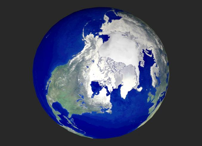
NASA/JPL-Caltech. “WorldSRTM-ArcticGlobe.jpg” Online Image. Shuttle Radar Topography Mission. 16 May 2005 30kb. 679×491px. <http://photojournal.jpl.nasa.gov/jpegMod/PIA02970_modest.jpg>
This image shows an SRTM data set for the Arctic region. No credit. Use the requested "Courtesy NASA/JPL-Caltech." See JPL Image Policy. Original photo unmodified; Picasa2 made very little difference. Original can also be viewed at the NASA link above.
 WorldSRTM-Globes-picasa.jpg
NASA/JPL/NIMA. “WorldSRTM-Globes-picasa.jpg” Online Image. Shuttle Radar Topography Mission. 16 May 2005 41kb. 785×423px. <http://photojournal.jpl.nasa.gov/jpegMod/PIA03394_modest.jpg>
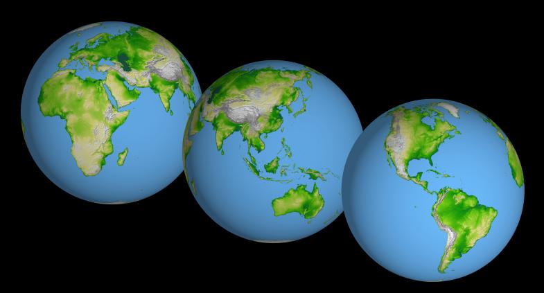
Orientation: North toward the top
Image Data: shaded and colored SRTM elevation model
Original Data Resolution: SRTM 1 arcsecond (about 30 meters or 98 feet)
Date Acquired: February 2000
This image shows an SRTM data set for world. It presents three globes one behind the other, each turned to present a complete view of the Earth's surface. It was created from an original map produced from data obtained by NASA's Shuttle Radar Topography Mission (SRTM). Using Google's free Picasa2 program, the color and lighting were enhanced and then sharpened to obtain the image above. The original map is available at the NASA link above.
 WorldSRTM-Mercator-picasa.jpg
NASA/JPL/NIMA. “WorldSRTM-Mercator-picasa.jpg” Online Image. Shuttle Radar Topography Mission. 16 May 2005 48kb. 892×374px. <http://photojournal.jpl.nasa.gov/jpegMod/PIA03395_modest.jpg>
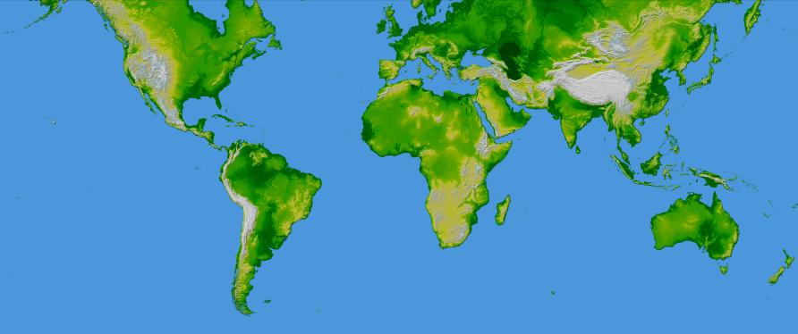
Orientation: North toward the top, Mercator projection
Image Data: shaded and colored SRTM elevation model
Original Data Resolution: SRTM 1 arcsecond (about 30 meters or 98 feet)
Date Acquired: February 2000
This image shows an SRTM data set for the world in a Mercator projection. It was created from an original map produced from data obtained by NASA's Shuttle Radar Topography Mission (SRTM). Using Google's free Picasa2 program, the color and lighting were enhanced and then sharpened to obtain the image above. The original map is available at the NASA link above.
WorldSRTM-MercatorLarge-picasa.jpg
NASA/JPL/NIMA. “WorldSRTM-MercatorLarge-picasa.jpg” Online Image. Earth Observatory. 16 May 2005 1.79MB. 5400×2262px. <http://earthobservatory.nasa.gov/Newsroom/NewImages/Images/PIA03395_lrg.jpg>
This image shows an SRTM data set for the world in a Mercator projection. It was created from an original map produced from data obtained by NASA's Shuttle Radar Topography Mission (SRTM). Using Google's free Picasa2 program, the color and lighting were enhanced and then sharpened to obtain the image above. The original map is available at the NASA link above.
 WorldSRTM-MercatorTile-picasa.jpg
NASA/JPL/NIMA. “WorldSRTM-MercatorTile-picasa.jpg” Online Image. Shuttle Radar Topography Mission. 16 May 2005 5kb. 320×134px. <http://photojournal.jpl.nasa.gov/jpegMod/PIA03395_modest.jpg>
This image shows an SRTM data set for the world in a Mercator projection. It's lightened in a sepia-tone, primarily for use as a background image tile for EarthChronicle.com Atlas webpages. It was created from an original map WorldSRTM-Mercator-picasa.jpg produced from data obtained by NASA's Shuttle Radar Topography Mission (SRTM). The world map was resized to 320 pixels wide using a trial version of Adobe Photoshop. Using Google's free Picasa2 program, the picture was lightened using the sepia button twice. The original image can be viewed at the NASA link above.