| |
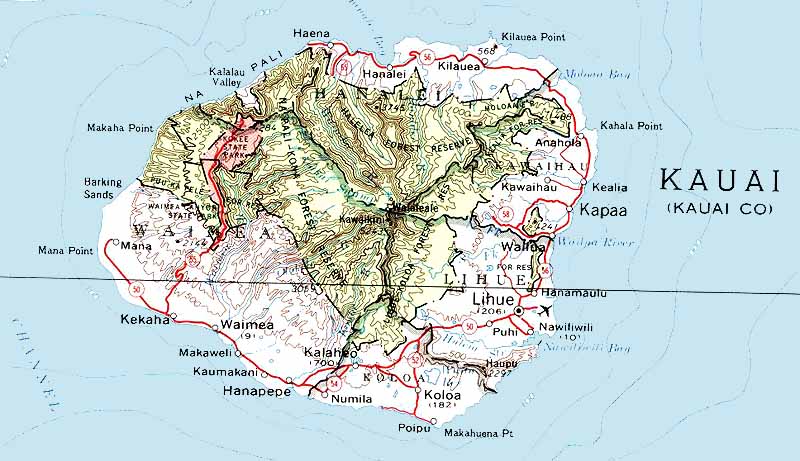
General map of the Hawaian groupGeneral map of HawaiiIndividal maps of each islandKahoolaweThis island is completely unhabitated. It has no tourist infrastructures. Kahoolawe (vegetation map very detailed) Basic map of Kahoolawe Kahoolawe Very deatailed. Good topographic map Kauai Probably one of the best maps of Kauai very detailed Kauai Another great map of the island (large file) Kaui (large file) State Parks , National Parks and Natural Reserves can be clearly seen. Kauai (small file) Lanai Lanai Good map of the island Lanai Road Map (with road distances between towns) Mauai Maui Very large file but very detailed map You can also see the island of Molokini Maui Great map also interactive choose a place click on it and it will give you information on the place Molokai Molokai Molokai (Molokai Hawaian by Nature) Molokai Great map also interactive choose a place click on it and it will give you information on the place Oahu Oahu Good highway map Oahu Oahu Great map also interactive choose a place click on it and it will give you information on the place Niihau Niihau You see the main road and small towns. You can also see Lehua Island Hawaii Big Island Hawaii Big Island Big Island Hawaii Great map also interactive choose a place click on it and it will give you information on the place Hawai Hotels map See AlsoCook Islands mapsMarquesas Islands - Les Iles Marquises Maps of Hawaii Maps of New Caledonia - Cartes des iles de la Nouvelle-Caledonie Cartes des Iles Maurices - Mauritius maps Cara das Islas Malvinas - Maps of the Falkland Islands |
||