|
As a consequence of the partition
of the indo-Pakistan Sub-Continent , in 1947 India and Pakistan became
independent sovereign states. The irrigation system which existed at that
time was divided between the two countries which resulted in an
international water dispute which was finally resolved by signing of the
Indus Water Treaty in 1960 under the aegis of World bank. The treaty
assigned to India the three eastern rivers (Ravi, Beas and Sutlej) and to
Pakistan the three Western rivers (Indus, Jhelum and Chenab, and provided
for construction of transfer of irrigation supplies from the western
rivers to areas in Pakistan formerly served by the eastern rivers. In
addition it included construction of some development works to compensate
for perpetual loss of eastern river's water. The works proposed under the
Treaty were two dams, five barrages, one siphon and eight inter-river link
canals. Mangla Dam on Jhelum and Tarbela on Indus river were the tow dams.
|
| |
MAIN IDEA OF
CONSTRUCTION
|
| |
Mangla Dam project was actually
conceived in 1950's as a multipurpose project to be constructed at a
place called Mangla across river Jhelum located 20 miles upstream of
Jhelum town. The initial investigation and its feasibility studies were
completed in 1958. The project was later included in the Indus Basin
project which was completed during 1960-71 except Tarbela Dam Project
which started partial operation in 1975-76.
|
 |
|
|
| |
| |
The construction of Mangla Dam was started in 1962 and completed in 1967.
BACK TO TOP
|
|
|
|
The project consists of two dams, tow dykes to
contain reservoir, tow spillways for outflow regulations, intake structure
with five tunnels, a power house and a tailrace canal. Various project
components are briefly described
in following paras.
|
|
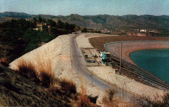
Main Dam
|
|
The Main Dam is located at Mangla on the river Jhelum.
It is an earth-fill
type dam with maximum height of 380 ft. above river bed with a crest length
of 11,000 ft (3,353 meters).
The Main Spillway is a gated concrete structure of
submerged orifice type with nine radial gated 36'x40'
capable of passing a peak flood of 870,000 cusecs at maximum
conservation level of 1202 ft. S.P.D. The Main spillway consists of an
approach channel head works, two-stage stilling basin with too chutes and
pools separated by a weir and a tailrace channel leading into the river
Jhelum.
|
|
 |
|
Jari Dam
|
|
It is located across Jari Nallah 17 miles from Main Dam off New Mirpur
City. It is also an earth-fill Dam with maximum height of 274 ft. on river
bed and a crest length of 14,500 ft. There is an irrigation tunnel of
7 ft. diameter discharging into Jari Nullah through a hydraulically operated
irrigation valve with discharging capacity of 175 cusecs at full reservoir
level. The releases through this tunnel ara made to supplement irrigation
supplies during low reservoir level period when Jari pocket is separated
from Main Reservoir at elevation 1110 ft SPD.
Jari Kas Park is located at Jari. The distance
from Mirpur City is 14 KM. Nice Park and Beautiful Public place for
visitors. There is also a small cafeteria for refreshment.
|
|
 |
|
Sukian Dyke
|
|
It is located on south-east periphery of Main Reservoir with maximum
height of 144 ft. and a crest length of 16,900 ft.
|
|
Picture Not Available
BACK TO TOP |
|
Kakra Dyke
|
|
It is constructed on left rim of Jari Dam, with
maximum height of 139 ft. and a crest length of 3,400 ft. |
|
Picture Not Available
BACK TO TOP |
|
|
|
|
Power House |
|
The Power House has been constructed at the toe of intake
embankment at the ground surface elevation of 865 ft. S.P.D. The water to
Power House is supplied through five steel lined tunnel of 30/26 ft.
diameter. Each tunnel is designed to feed two generating units. The
Present installed capacity at Power Station is 1000 Megawatts with 15% over
load generating capacity at high reservoir level. The Power House tailrace
discharges into New Bong Canal which has a length of 25,000 ft. with
discharge capacity of about 49,000 cusecs, and terminates at an automatic
gate control headworks at 7miles downstream located near old Bong Escape
headworks. |
|
 |
|
|
FISHERIES |
|
|
| The Scheme of Fisheries
Development at Mangla is in operation since 1967. The Aim of This scheme is
to enhance fish production in the reservoir by stocking it with quality fish
seed. Fishing rights in Mangla reservoir were leased out for first time in
1971-72. Since then 63.3 million rupees have been earned through sale of
fishing rights and about 14,700 metric tons of fish has been produced. The
important species of fish found in Mangla reservoir are Rohu, Mori, Thaila,
Mahsher, Mullee, Singhara, Common carp, Silver Carp and grass Carp. |
A
Small fish hatchery is in operation which is insufficient to meet fish seed
requirement of the water body. now it is being extended with the aid of
United Nations Development Program (UNDP). A glass jar Hatchery is being
constructed along with rearing pond complex. After completion of this
project 7 million fish seed of quality fish will be stocked in the reservoir
annually and ultimately the fish production will be raised five times.
BACK TO TOP |
|
|
|

